Create A Free .com.np Website In Nepal If you are looking for a free, easy and step-by-step guide on how to start a lifetime free .com.np blog then, you have come to the right place. I will try my best to guide you through this procedure. This article has been enormously helpful for viewers. Take a look! Everybody wishes to have their own website especially students(ICT), online researchers, gamers, etc but what comes in between us and our own website(blog) is the expensive price of the domain name and web hosting service. So today, I am here to teach you, how to create a website for free with .com.np domain and host it using free web hosting services . There are a number of online companies providing free websites (domain name with web hosting) like WordPress, Blogger, Wix, etc but with something fishy going on. Owning your own domain name looks far more professional than having your site on someone else’s domain (like www.yourdomain.freewebsite.com), and it’s super...
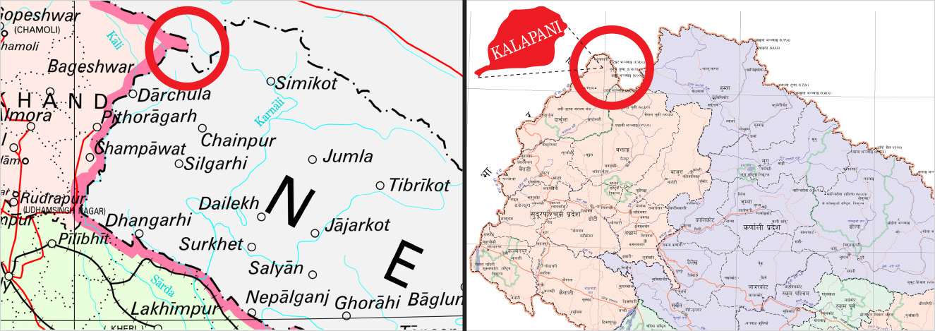
Greater Nepal In Quest Of Boundary | India’s new political map places disputed territory of Kalapani inside its own borders on November 2, 2019
Greater Nepal In Quest Of Boundary
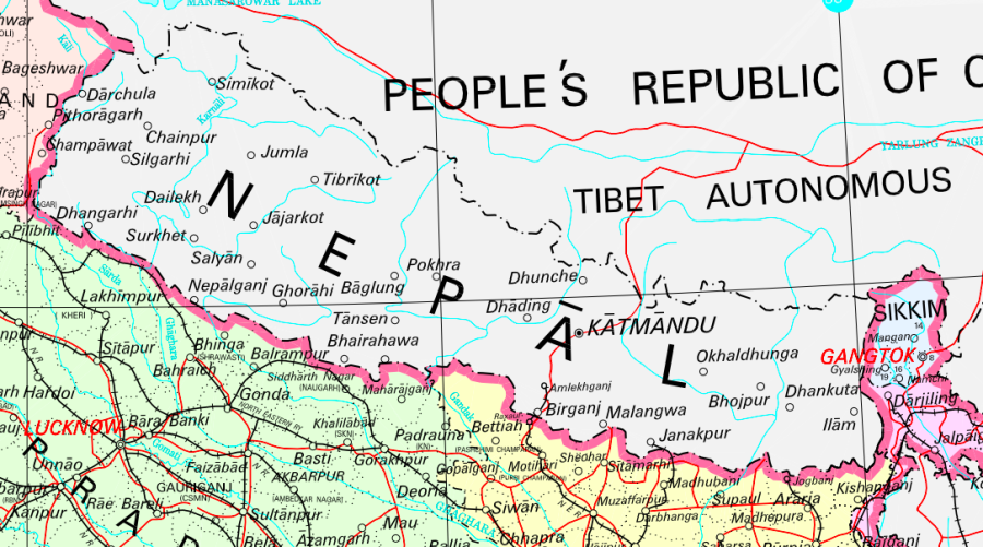
India’s new political map places disputed territory of Kalapani inside its own borders on November 2, 2019
Nepal has long claimed Kalapani as part of its territory as per the Sugauli Treaty signed between Nepal and the then East India Company.

The Survey Department has taken issue with a new Indian political map that places the disputed territory of Kalapani within its territory, a scenario Nepali officials described as the “status quo”.
The Indian Ministry of Home Affairs on Sunday released a new political map after India formally split up the disputed Jammu and Kashmir state into two federal territories, in line with an August move by the Narendra Modi government to rescind Kashmir’s autonomy.
“Our technicians and officials have examined the new Indian political map,” said Prakash Joshi, director-general of the Survey Department. He, however, refused to share details because he had to “communicate the matter with higher authorities first.”
“I will brief the higher authorities, including the foreign secretary and my senior officials at the ministry first,” Joshi told the Post. “I cannot share the findings right now with the media.”
Survey Department officials, who did not wish to be named, told the Post that disputed tracts of land between Nepal and India, like Kalapani and Lipu Lekh, are placed inside Indian territory.
If Nepal has any objection to the new political map of India, it is the job of the Ministry of Foreign Affairs to communicate with New Delhi through diplomatic channels, the officials said.
Nepal has long been claiming that Kalapani, Lipu Lekh, and Limphuyadhara are very much part of its territory. The Survey Department has even produced maps of Nepal that show all three disputed pieces of land as a part of Nepal.
“The Survey Department has prepared a map of Nepal that includes Kalapani as a part of Nepal and has urged all government and private offices to use the official map of Nepal released by the department,” said Ganesh Bhatta, former director-general of the department.
As Nepal has always included Kalapani within its territory and India within its, the piece of land has remained a matter of dispute, said Bhatta.
Nepal, however, has had opportunities at least on two occasions in the past to sort out its border issues with India.
When China and India reached an agreement to build bilateral trade corridors through Lipu Lekh via the Indian state of Uttarakhand in 2015, Nepal had taken up the issue with both countries.
The then government had written to both New Delhi and Beijing about the agreement, but “we never received satisfactory responses,” government officials had told the Post in 2017.
Again in 2017, foreign relations analysts had told the Post that the Doklam standoff between India and China could be a good opportunity for Nepal to raise the border issue with New Delhi. That opportunity, however, was missed.
Over the past two years, there has not been much communication between Kathmandu and New Delhi regarding disputed territories like Kalapani, even though officials from both sides have agreed to sort out border issues.
The Kalapani dispute began in 1962 after India withdrew all its border outposts from the northern belt of Nepal, according to Buddhi Narayan Shrestha, former director-general of the Survey Department.
Although claimed by Nepal, Kalapani has been occupied by India's security forces since the 1962 war with China.
During Matrika Prasad Koirala’s prime ministership in 1952, Nepal allowed India to station its troops in Kathmandu and on Nepal’s northern border, including Kalapani. India later withdrew from all other posts and stationed its troops on its side of the border of Kalapani. But later, India moved into Nepali territory, making Kalapani a disputed area between Nepal and India, according to Shrestha.
During the third meeting of Nepal-India Joint Commission in Kathmandu in 2014, both sides had agreed to assign the task of resolving the boundary dispute in Kalapani and Susta to the Foreign Secretaries of Nepal and India, but there has been no major development so far.
However, Nepal and India have prepared 182 sheets of boundary maps, besides Kalapani and Susta, and as per the agreed boundary maps, Nepal and India have begun the demarcation of the border, which is likely to be completed in 2022.
During the Fifth Meeting of the Nepal-India Joint Commission in Kathmandu on August 21 and 22, the foreign ministers of both countries had directed a foreign secretary-level mechanism to prioritize work on the outstanding boundary issues with technical input from the Boundary Working Group. Nepal and India had formed the working group at the Surveyor General level to settle all boundary issues.
The dispute over Lipu Lekh emerged after India and China agreed to build a bilateral trade corridor through Lipu Lekh in 2014, contesting Nepal’s claim. Nepal has been opposing the bilateral agreement between India and China on Lipu Lekh on the grounds that it is against the provisions of the 1816 Sugauli Treaty signed between Nepal and India.
Addressing the International Relations Committee of House of Representatives on February 10, Foreign Minister Pradeep Gyawali had said that India and China could not discuss the matter or make it a bilateral trading route without the presence of Nepal.
“We do not accept Lipu Lekh as a tri-junction between Nepal, India, and China,” Gyawali had told the House committee. “It will only be finalized after Nepal and India complete final demarcations. No country can discuss Nepal’s territory in our absence.”
Even as pressure mounts, Oli administration remains silent over Kalapani on November 5, 2019
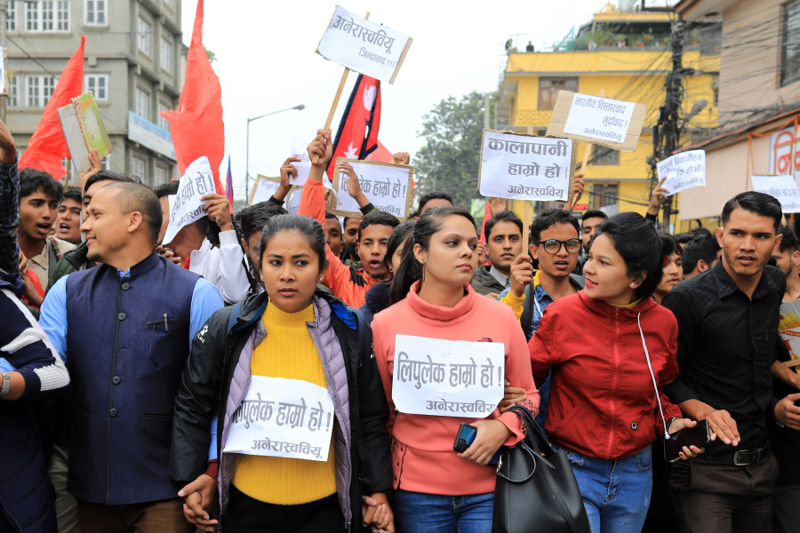
A new map released by the Indian government has placed Kalapani inside Indian borders, drawing widespread condemnation on social media.

The KP Sharma Oli administration has remained silent over a new political map released by India that places Kalapani, a disputed tract of land between Nepal and India, within Indian borders.
The Post first reported on Monday about the Indian government’s new map, released by the Indian Ministry of Home Affairs, which has since ignited a social media storm. But the ruling Nepali Communist Party, which had contested the 2017 elections as a nationalist force in the wake of the 2015 Indian blockade, and the Ministry of Foreign Affairs has yet to take a public position, although discussions were ongoing late into Tuesday.
The Parliament’s State Affairs and Good Governance Committee has taken note of the map and will summon concerned officials to discuss the matter, said committee member Pampha Bhusal.
A Tuesday meeting of the committee decided to summon officials from the Ministry of Foreign Affairs, the Home Ministry, Ministry of Land Reform and Management, and the Survey Department on Thursday.
“We’ve learned that the new Indian map has placed Kalapani in its territory, but we want to know the government’s position and what it is doing,” Bhusal told the Post.
A number of political parties and elected representatives from Darchula district, which includes Kalapani have sought the government’s official position on the issue.
Ganesh Singh Thagunna, a Member of Parliament from Darchula from the ruling Nepal Communist Party, said he was opposed to the Indian move but that it is the job of the government to raise the issue with New Delhi.
“I am concerned as the elected people’s representative. I came to know that our land has been placed in Indian territory,” said Thagunna. “The government should take immediate steps with India and raise the issue through diplomatic channels. We have to put pressure on the government to tell India to correct the map.”
The Post repeatedly reached out to Foreign Minister Pradeep Gyawali, Foreign Secretary Shankar Das Bairagi, Spokesperson at Foreign Ministry Bharat Raj Paudyal, and ruling party Spokesperson Narayan Kaji Shrestha but they were unavailable for comment. Shrestha told the Post that he was traveling outside Kathmandu and was not aware of the new Indian map.
One Foreign Ministry official, who did not wish to be named as he was not authorized to speak to the media, said that the ministry was trying to verify the new Indian map—it was released after India formally split up the disputed Jammu and Kashmir state into two federal territories—before taking an official position.
“Since this is a serious diplomatic issue related to our boundary, there is a mechanism at the foreign secretary-level to look into the matter, so it will deal with the issue accordingly,” the official said.
Senior officials at the Survey Department examined the new political map of India on Monday and Tuesday and reconfirmed to the Post that Kalapani has been placed inside Indian territory. Although Kalapani was once comfortably in Nepali territory, since 1962, it has been occupied by the Indian armed forces, according to historians and surveyors.
The Survey Department was supposed to brief higher authorities, including the Ministry of Land Reform and Management, and the Ministry of Foreign Affairs on Tuesday but officials were unable to get time with ministry officials, they said.
“We hope we will get time for a briefing soon as there is a lot of pressure on us and other government entities,” said a senior Survey Department official who requested anonymity, citing the sensitivity of the issue.
Bishwa Prakash Sharma, a spokesperson for the primary opposition Nepali Congress, said that the party’s attention has been drawn to the new map released by New Delhi.
“Kalapani and Lipu Lekh are our inalienable parts. The Nepal government should take immediate steps and make its position public. Questions being raised about our soil from anywhere are objectionable and unacceptable,” he said on Twitter, addressing the prime minister.
Two political parties—the Rashtriya Prajatantra Party and the Nepal Majdoor Kisan Party—also issued press statements on Tuesday condemning the Indian map and seeking an official explanation from the government and Prime Minister KP Sharma Oli.
Dinesh Bhattarai, who served as foreign affairs advisor to the late Sushil Koirala, told the Post that the Koirala government, in 2015, had protested with India and China after the two countries decided to develop a bilateral trade route through Lipu Lekh, a tri-juncture between Nepal, India, and China, and closed off the Kalapani area.
“The decision was made in May 2015 and in June, we protested to both India and China,” said Bhattarai. “But none of the so-called nationalist governments formed after the Koirala government has taken up the issue with India and China.”
Bhattarai said the government first has to to make its position public and then the ruling and opposition parties should both raise the issue.
“What we are waiting to see now is if they have the guts to raise the issue,” he said.
The government finally comments on the new Indian map but takes no firm position on November 6, 2019
In a press statement, the Foreign Ministry refers to media reports and commentary before asserting that the matter would be resolved diplomatically.

The KP Sharma Oli administration on Wednesday said that its attention had been drawn to news and commentary regarding the placement of Kalapani on a new political map released by India.
Refraining from commenting directly on India’s new map, the statement, released by the Ministry of Foreign Affairs, says, “The Nepal government is clear about Kalapani being part of Nepal’s territory.”
The Post first reported on Monday that the new political map—released after India formally split up the disputed Jammu and Kashmir state into two federal territories—has placed the territory of Kalapani within its borders.
The Foreign Ministry statement on Wednesday came after a briefing by a Survey Department team led by its Director-General Prakash Joshi to secretaries from the Ministry of Foreign Affairs, Ministry of Home Affairs, and Ministry of Land Reform and Management.
At least two officials familiar with developments told the Post that it was surprising that the Foreign Ministry had issued a statement specifically mentioning media reports, despite being briefed on the matter by the Survey Department.
“Government secretaries were clearly briefed that some parts of Nepali land, including Kalapani, have been placed inside Indian borders in India’s new political map,” an official told the Post on condition of anonymity, citing the sensitivity of the matter.
“During the meeting, all three secretaries were convinced of the gravity and sensitivity of the issue and decided to immediately raise it with India through diplomatic channels,” said the other official. “The Foreign Ministry cannot issue a statement based on media reports because it has already been briefed by the concerned officials.”
The Survey Department had informed the government secretaries that the time had come to bring up the Kalapani issue with India via political and diplomatic channels.
“India has maintained its own ‘status quo’ while carving its boundary with Nepal. It’s time to address it,” an official familiar with the briefing said, describing the conversation between Survey Department officials and the government secretaries.
The third meeting of Nepal-India Joint Commission at the foreign minister-level in 2014 agreed to form a joint panel at the foreign secretary-level to resolve boundary disputes in Susta and Kalapani between Nepal and India, but no progress was reported at the last joint commission meeting held in Kathmandu in August.
Durga Prasad Bhattarai, a former foreign secretary, said that Nepal should invest more during times of calm to resolve the boundary crisis rather than becoming confused when a crisis appears.
“In peacetime, we have to take up the issue with whom we have disputes. If anything cannot be sorted out, we should clearly say that this issue remains unsettled. In certain cases, we can hold back because boundary disputes happen all over the world and they may not settle within a designated time. But we have to put the things forward in a transparent manner,” said Bhattarai.
Others pointed out that the statement is littered with errors. The statement, which is in Nepali, does not even have the name and designation of the undersigned, while the signature itself is unclear. As of press time, the statement had not been released in English, despite it concerning an international border issue.
The statement also makes no reference to Nepal’s claim over Limpiyadhura and Lipu Lekh, both areas which, in addition to Kalapani, have also been claimed as part of Nepali territory but are placed within Indian borders in the new map.
Pradhumna Shah, a former ambassador, said that it was not wise to release a press statement after something so critical appears in the media.
“In the past, the ministry has issued several statements repeatedly, correcting one after another. Whether it is SAARC or Venezuela or the Indo-Pacific Strategy, the Foreign Ministry has issued multiple statements after reactions and comments in the media,” said Shah. “The ministry should be consistent and it needs to respond before there is noise in the media.”
Shah, who served at the Foreign Ministry for a long time, said that if any crucial issue surfaces, the foreign minister or foreign secretary can immediately call upon their counterparts to voice their concern.
“It does India no good to maintain a boundary dispute with Nepal for such a long time as it only props up anti-Indian sentiment,” said Shah. “Nepal, on the other hand, should be proactive to settle the dispute because it is an important and sensitive issue for us.”
The Foreign Ministry, in its statement, has said that outstanding border-related issues between the two countries should be resolved mutually and that the Nepal government won’t accept any unilateral decisions.
“The Nepal government is committed to defending its international borders and is firm on its position that border problems between the two neighboring countries should be resolved diplomatically, based on historical documents and concrete evidence,” says the statement. “Foreign secretaries of the two countries have been mandated to resolve border-related issues.”
Rajan Bhattarai, the foreign relations advisor to Prime Minister KP Sharma Oli, told the Post that shortcomings from the government’s side in its immediate response could be because the concerned offices and officials did not have an “authenticated map”.
“If concerned officials have received the maps, they should be verified technically before making a position. Once officials find out the differences between the old and new maps, we have to raise the issue with India,” said Bhattarai. “It is our clear position that unilateral actions taken by anyone cannot be accepted.”
According to Bhattarai, Nepal’s diplomatic apparatus will take up the issue with India once the new map has been examined thoroughly. The map was uploaded on the official website of the Indian government’s Ministry of Home Affairs.
Comments
Post a Comment